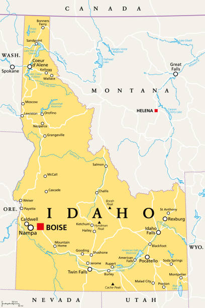
Idaho, ID, political map with the capital Boise, borders, important cities, rivers and lakes. State in the Pacific Northwest region of the Western United States of America, nicknamed Gem State. Vector
Browse 90+ idaho falls id stock illustrations and vector graphics available royalty-free, or start a new search to explore more great stock images and vector art.
Idaho, ID, political map with the capital Boise, borders, important cities, rivers and lakes. State in the Pacific Northwest region of the Western United States of America, nicknamed Gem State. Vector

Amazing vector flag of Idaho state.

Cartoon map of IDAHO I have used http://legacy.lib.utexas.edu/maps/us_2001/idaho_ref_2001.jpg address as the reference to draw the basic map outlines with Illustrator CS5 software, other themes were created by myself.

Linear Idaho Falls Idaho Temple against the background of the sun in the form of an emblem

Idaho Falls ID City Vector Road Map Blue Text. All source data is in the public domain. U.S. Census Bureau Census Tiger. Used Layers: areawater, linearwater, roads.

IDAHO I have used http://legacy.lib.utexas.edu/maps/united_states/united_states_pol02.jpg address as the reference to draw the basic map outlines with Illustrator CS5 software, other themes were created by

Vector Idaho State Animals Map https://maps.lib.utexas.edu/maps/us_2001/idaho_ref_2001.jpg
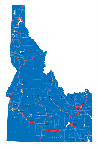
Detailed map of Idaho state,in vector format,with county borders,roads and major cities.

Rocky Mountain region of the United States, political map. The Rocky Mountains, Rockies for short, divide the western United States from the Great Plains. Colorado, Idaho, Montana, Wyoming, and Utah.

Downloadable outline vector map of Idaho state of United States of America.

Vector Illustration of a City Street Map of Idaho Falls, Idaho, USA. Scale 1:60,000. All source data is in the public domain. U.S. Geological Survey, US Topo Used Layers: USGS The National Map: National Hydrography Dataset (NHD) USGS The National Map: National Transportation Dataset (NTD)

Rocky Mountain region of the United States, gray political map. Rocky Mountains, Rockies for short, divide the western United States from the Great Plains. Colorado, Idaho, Montana, Wyoming, and Utah.

Vector Idaho State Travel Map https://maps.lib.utexas.edu/maps/us_2001/idaho_ref_2001.jpg

Idaho, ID, gray political map with capital Boise, borders, important cities, rivers and lakes. State in the Pacific Northwest region of the Western United States of America nicknamed Gem State. Vector

State of Idaho vector flag. Vector illustration. United States of America.

Map of Bonneville County - Idaho, on a blue and red colored background. The blue color represents the Democratic Party and the red color represents the Republican Party. White stars are placed above and below the map. Vector Illustration (EPS file, well layered and grouped). Easy to edit, manipulate, resize or colorize. Vector and Jpeg file of different sizes.

Word cloud map of Idaho state. Cities list collage

http://s017.radikal.ru/i431/1111/c3/e30e02be8a61.jpg

Cartoon map of IDAHOI have used http://legacy.lib.utexas.edu/maps/us_2001/idaho_ref_2001.jpgaddress as the reference to draw the basic map outlines with Illustrator CS5 software, other themes were created by myself.

Map of Bonneville County - Idaho, in a trendy vintage style. Beautiful retro illustration with old textured paper and light rays in the background (colors used: blue, green, beige and black for the outline). Vector Illustration (EPS file, well layered and grouped). Easy to edit, manipulate, resize or colorize. Vector and Jpeg file of different sizes.

Maps of Bonneville County - Idaho, on blue and red backgrounds. Four map versions included in the bundle: - One map on a blank blue background. - One map on a blue background with the word "Democrat". - One map on a blank red background. - One map on a red background with the word "Republican". Vector Illustration (EPS file, well layered and grouped). Easy to edit, manipulate, resize or colorize. Vector and Jpeg file of different sizes.

3D Map of Bonneville County - Idaho, isolated on a blank and gray background, with a dropshadow. Vector Illustration (EPS file, well layered and grouped). Easy to edit, manipulate, resize or colorize. Vector and Jpeg file of different sizes.

Map of Bonneville County - Idaho, with a realistic paper cut effect isolated on white background. Trendy paper cutout effect. Vector Illustration (EPS file, well layered and grouped). Easy to edit, manipulate, resize or colorize. Vector and Jpeg file of different sizes.

Detailed map of Idaho with icons of organizations providing services, government organizations and structures.

Word cloud map of Idaho state. Cities list collage and road arrow sign

Large and detailed map of Bonneville county in Idaho, USA.

Idaho US State Vector Road Map Grey. All source data is in the public domain. Roads, Water, Regions, Urban Areas: Made with Natural Earth. https://www.naturalearthdata.com/downloads/10m-physical-vectors/ https://www.naturalearthdata.com/downloads/10m-cultural-vectors/

Idaho Idaho Falls Stamp with National Flag and Postmark

Idaho Vintage Postcard with Flag Stamp and City Postmarks

Idaho, ID - detailed political map of US state. Administrative map divided into counties. Thin black outline map with county name labels. Vector illustration

Idaho, ID - detailed political map of US state. Administrative map divided into counties. Thin blank black outline map. Vector illustration

Idaho Falls ID City Vector Road Map Blue Horizontal. All source data is in the public domain. U.S. Census Bureau Census Tiger. Used Layers: areawater, linearwater, roads.

Amazing vector flag of Idaho state.

Map of Bonneville County - Idaho, isolated on a blank background and with his name on a red ribbon. Vector Illustration (EPS file, well layered and grouped). Easy to edit, manipulate, resize or colorize. Vector and Jpeg file of different sizes.

Map of Bonneville County - Idaho, with a large group of people. The faces are blue and red and represent patriots. The color blue for the Democratic Party and the color red for the Republican Party. Conceptual creative map, can symbolize the unity, cooperation, teamwork, patriotism... Vector Illustration (EPS file, well layered and grouped). Easy to edit, manipulate, resize or colorize. Vector and Jpeg file of different sizes.

Idaho Idaho Falls Gold Typography Stamp Design

Idaho state map over USA flag badge. Idaho state map silhouette overlaid with the United States flag.

Map of Bonneville County - Idaho folded with design elements. Blue map with grid lines, isolated on a blank background. Included in the illustration: Map pins, pushpins, marbles, stars, speech bubbles, people, and a map of the United States. Vector Illustration (EPS file, well layered and grouped). Easy to edit, manipulate, resize or colorize. Vector and Jpeg file of different sizes.

Large and detailed map of Bonneville county in Idaho, USA.

Large and detailed map of Bonneville county in Idaho, USA.

Map of Bonneville County - Idaho for your own design. Three maps with editable stroke included in the bundle: - One black map on a white background. - One line map with only a thin black outline in a line art style (you can adjust the stroke weight as you want). - One map on a blank transparent background (for change background or texture). The layers are named to facilitate your customization. Vector Illustration (EPS file, well layered and grouped). Easy to edit, manipulate, resize or colorize. Vector and Jpeg file of different sizes.