Soil layer infographics, earth texture horizon, subsoil land and underground, vector cross section. Geology soil layer and ground structure diagram with organic topsoil, weathered rock and bedrock
Browse 310+ soil layers diagram stock illustrations and vector graphics available royalty-free, or start a new search to explore more great stock images and vector art.
Soil layer infographics, earth texture horizon, subsoil land and underground, vector cross section. Geology soil layer and ground structure diagram with organic topsoil, weathered rock and bedrock

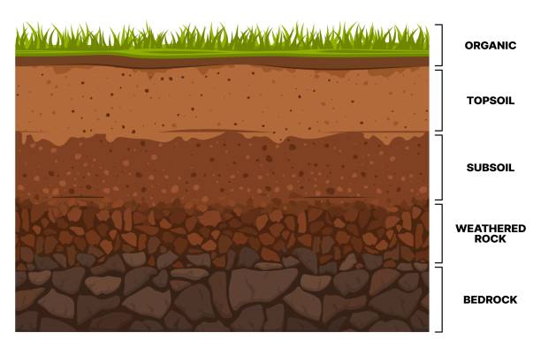
Soil layer infographic, earth geology formation. Bedrock, weathered rock, subsoil, topsoil and organic layer cross section ground and underground surface. Vector infographics chart cartoon design

3D Isometric Flat Vector Conceptual Illustration of Artesian Aquifer, Supplying Water to the House
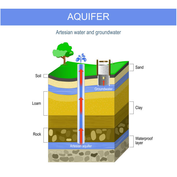
Artesian water and Groundwater. Aquifer and artesian well. cross section of soil with sand layer, gravel, loam, clay, and rock. vector illustration.
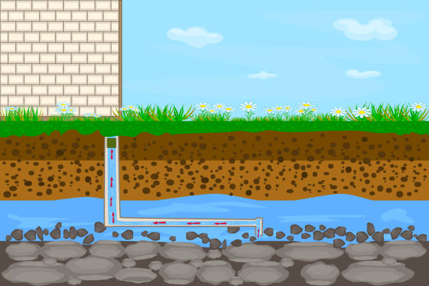
Drilling water well and supplying water to house. Groundwater and soil layers. Stock vector illustration
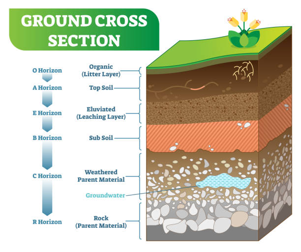
Ground Cross Section vector illustration with organic, topsoil, subsoil and other horizon levels. Geological information poster.
Dirt layers. Soil layer scheme with grass and roots, earth texture and stones vector illustration

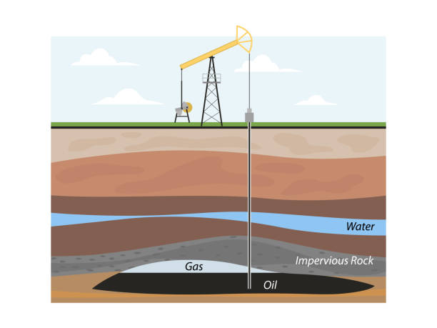
Oil extraction. Conventional drilling. Earth layers.

Soil layer scheme with grass, earth texture, groundwater and stones. Cross section of humus or organic and underground soil layers beneath. Stock vector illustration

Layers of soil diagram. Digital illustration.

3D Isometric Flat Vector Conceptual Illustration of Soil Compaction Method, Grounds Types

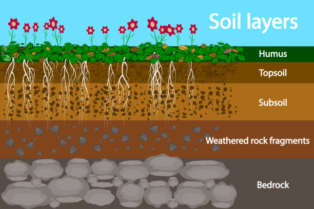
Soil layers with geological ground structure and materials outline diagram. Labeled educational scheme with land cross section vector illustration. Humus, topsoil, subsoil, rock fragments and bedrock

Earth atmosphere layers names. Colorful infographic poster with meteors, radiosonde, satellite and spaceship. Vector illustration, starry sky background.

Artesian water and Groundwater. Schematic of an artesian well. Typical aquifer cross-section. Vector diagram
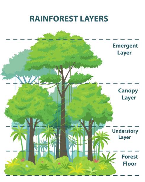
Rainforest layers educational banner or poster. Jungle vertical structure educational scheme. Emergent, canopy, understory and floor levels. Flat vector illustration

Lawn aeration process steps - before and after, lawn grass care service, gardening and landscape design, isolated illustration for article, infographics or instruction on white background, vector

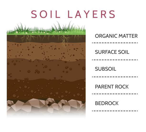
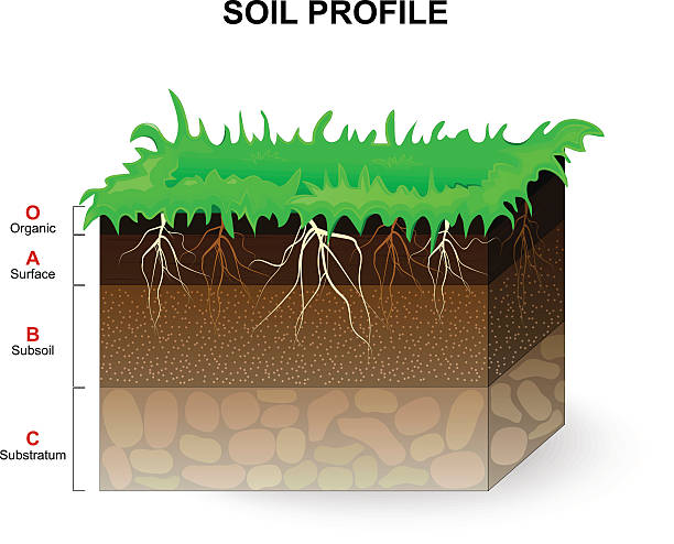
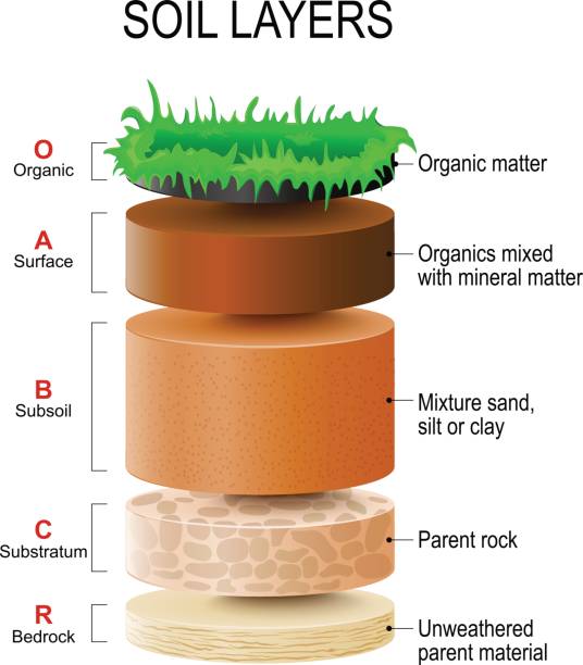
layers of the soil. A cross section of a soil, revealing horizons. Example of a soil profile: Organic, Surface, Subsoil, Substratum and Bedrock. Vector illustration.

Soil horizons are distinct layers of soil. Vector illustration flat design

Artesian aquifer. a cut of soil layers with clay, stones and ground water. Vector illustration flat design
Soil Profile and Soil horizons. Piece of land with green grass and plant roots. Vector illustration.

Soil layers diagram earth texture, stones. Ground with green grass on top. Mineral particles, sand, humus and stones, natural fertilizer. Geology infographics. Education for kids. Vector illustration.
Cross section of humus or organic and underground soil layers beneath. Vector illustration
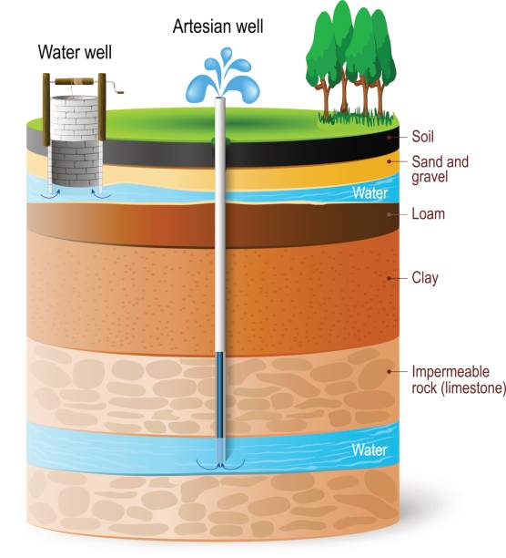
Artesian water and Groundwater. Schematic of an artesian well. Typical aquifer cross-section. Vector diagram
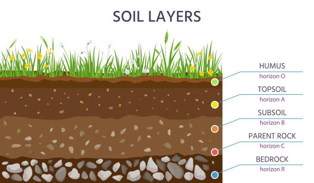
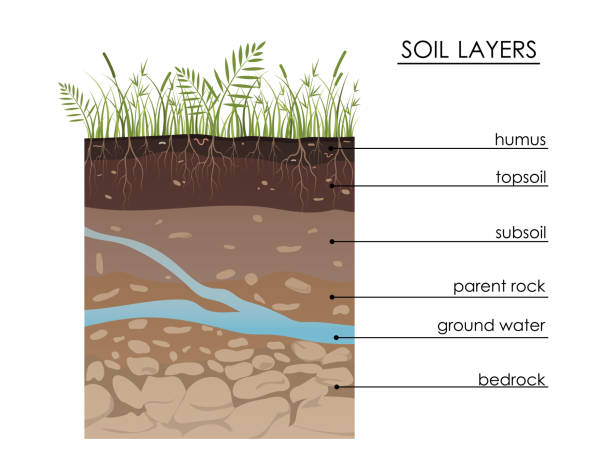
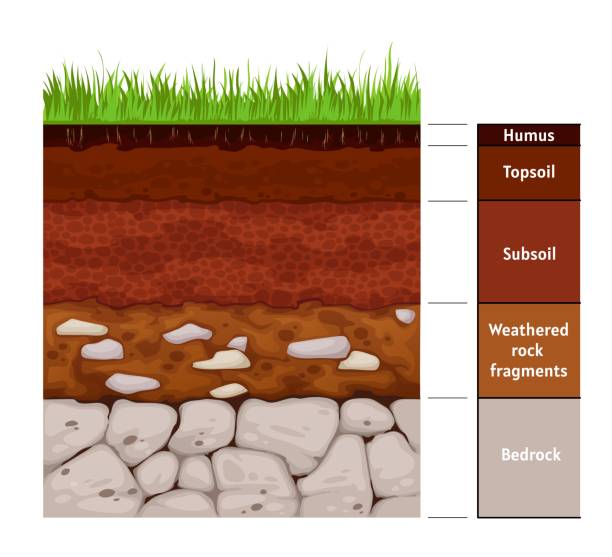
Soil structure layers, ground cross section education diagram. Grass, humus, topsoil, subsoil, parent rock and bedrock. Geology vector banner. Scientific scheme for underground learning
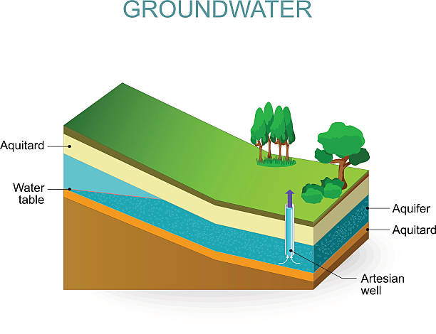
Groundwater and Artesian aquifer. Water table
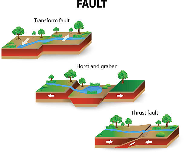
types of geological faults. Transform and Thrust fault, horst and graben. vector

Cross section of humus or organic and underground soil layers beneath. Stock vector illustration

Stenos Laws explain rock layer formation, key objects, soil layers, faults, lava. Outline diagram

Fountain from groundwater. Geyser comping out of ground. Water extraction. Artesian water and soil layers. Typical aquifer cross section infographics. Stock vector illustration

Atmosphere of Earth. Layer. Vector diagram
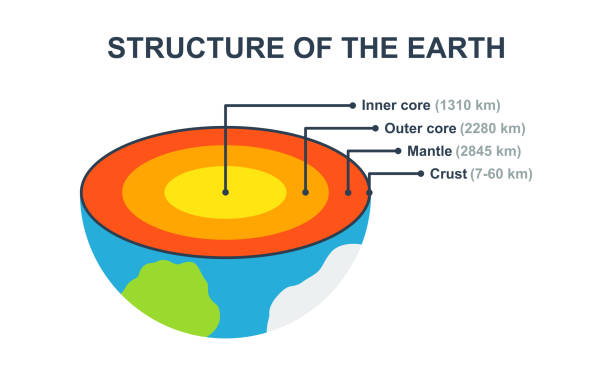
Structure of the Earth. Planet with section: inner and outer core, crust, mantle. Planet Earth from inner and cutaway.

Shale gas. schematic geology of natural gas resources

Soil organic matter sources are shown with above-ground inputs, below-ground roots, and soil organisms. Doodle style diagram

Soil structure layers, ground cross section education diagram. Grass, humus, topsoil, subsoil, parent rock and bedrock. Geology vector banner. Scientific scheme for underground learning
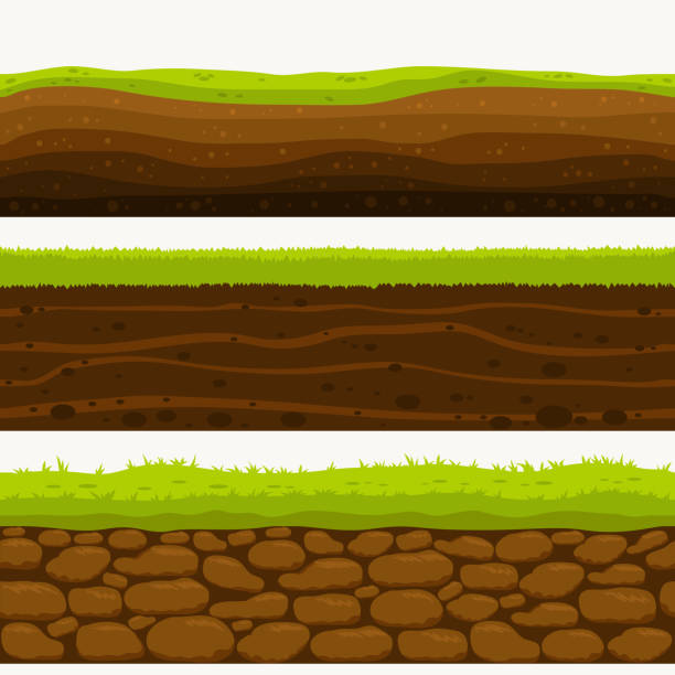
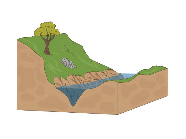
Soil Seamless layers. Landscapes of the earth. Layered dirt clay, ground layer with stones and grass on dirts, cliff texture, underground buried rock. The earth and green meadow. Set of realistic landscapes. vector.
soil layers. Soil Formation and Soil Horizons. Soil is a mixture of plant residue and fine mineral particles, which form layers. Vector diagram
Soil composition is illustrated with outline icons showing stratification, granular diversity, organic integration, component proportion, and moisture retention. Outline icons set
Soil layer infographic, earth geology formation bedrock, weathered rock fragments, subsoil, topsoil, humus. Vector infographics chart with soil cross section and underground surface

Wastewater subsoil leach field. Sewage treatment part system. Underground soil and water layers. Stock vector illustration

Soil horizons overview shows layers from organic O to bedrock, explaining soil formation and nutrient flow, key objects, topsoil, subsoil, bedrock. Doodle style diagram

Earth atmosphere layers names. Colorful infographic poster with meteors, radiosonde, satellite and spaceship. Vector illustration, starry sky background.
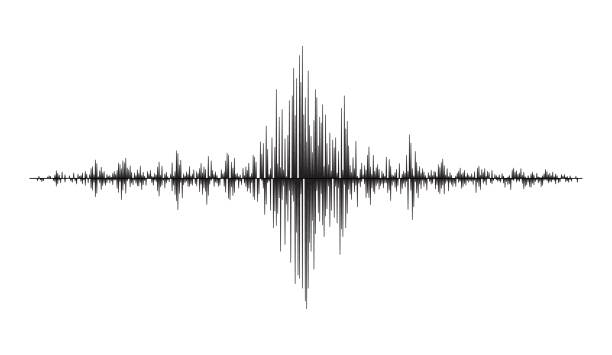
Earthquake seismograph wave, seismic frequency graph of seismometer, vector amplitude waveform. Earthquake magnitude frequency or seismograph wave of seismic vibration and amplitude wave diagram

Lawn aeration process steps, isometric - before and after, lawn grass care service, gardening and landscaping, isolated illustration for article, infographics or instruction on white background, vector isometry

Soil layers diagram, Geological study

A graphic illustration that demonstrates the different areas that make up the planet Earth. At the bottom left of the image is the lithosphere. It is colored tan and labeled "Lithosphere" and "Crust" with white lettering. The image's bottom right contains the hydrosphere. It is pictured as blue water. The atmosphere is at the top labeled with black letters. It consists of a light blue sky. A cow eats grass on top of the lithosphere next to a black and gray mountain capped with white snow. Blue and white clouds float past, and fish swim in the water.
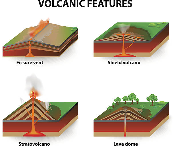
Types of volcano. Volcanic eruptions produce volcanoes of different shapes, depending on the type of eruption and geology. Fissure vents, Shield volcanoes, Lava domes and stratovolcano. diagram

Coal Formation. fossil fuel that derived from ancient fossilized vegetation.

Artesian water and soil layers. Typical aquifer cross-section. Geology infographics. Stock vector illustration

Soil Seamless layers surroundings with Rock stone. Water surface, volcanic lava, desert sand. The Earth Layered dirt clay, ground layer with stones and grass on dirts, cliff texture, underground buried rock. The earth and green meadow. Vector

Vector Illustration of The Water Cycle in Nature