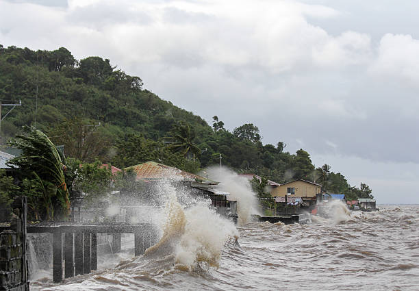
Laguna de bay, Philippines - November 8, 2013: Typhoon Haiyan's, an equivalent category 5 hurricane, endangering 25 million Filipinos in its path as it unleashed its fury. The hurricane is one of the biggest to ever hit land according to scientists.
Laguna de bay, Philippines - November 8, 2013: Typhoon Haiyan's, an equivalent category 5 hurricane, endangering 25 million Filipinos in its path as it unleashed its fury. The hurricane is one of the biggest to ever hit land according to scientists.
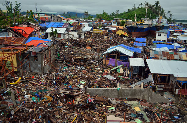
A sweeping shot of Barangay Anibong, taken in the Philippine city of Tacloban after Typhoon Haiyan struck in November 2013.

Tacloban City, Leyte, Philippines - Oct 2022: Aerial of Santo Nino Parish Church and downtown Tacloban and Real Street.

San Juanico Bridge: The Longest Bridge in the Philippines. Road bridge between the islands, top view. Summer and travel vacation concept.

Photograph image of a shop flooded during the supertyphoon Haiyan (Yolanda) in Tacloban City, Philippines.

Photograph image of a power post that fell on the street after being hit by the strong typhoon Yolanda (Haiyan) in Ormoc City, Philippines.

Tacloban City, Leyte, Philippines - Oct 2022: Aerial of Leyte Provincial Library and downtown Tacloban.

In the main Catholic church in Tacloban in the central Philippines.

Tacloban city, Leyte island, Philippines. Tropical landscape with panorama of the town, view from above. Town and sky with cumulus clouds. Summer and travel vacation concept.

Hand writing "Help Rebuild The Philippines", isolated on white background.

Tacloban, Leyte, Philippines - Oct 2022: A lineman installs new wiring while secured on an electric pole with a safety harness.

Panoramic of San Juanico Bridge, the longest bridge in the Philippines. Road bridge between the islands, top view. Summer and travel vacation concept.

Photograph image of several houses destroyed by supertyphoon Haiyan (Yolanda) in Tacloban City, Philippines.

Tropical landscape with panorama of Tacloban, aerial view. Town and sky with cumulus clouds. Leyte Island, Philippines. . Summer and travel vacation concept.

The San Juanico Bridge, view from Leyte, towards Samar. Philippines. Road bridge between the islands, top view.

Photograph image of Tacloban City , Philippines after it hit by super typhoon Haiyan (Yolanda) on November 8, 2013

Tacloban City, Leyte, Philippines - Oct 2022: Panoramic aerial of downtown Tacloban City.

Tacloban City, Leyte, Philippines - Oct 2022: Aerial of downtown Tacloban and the San Juanico Strait.

Map of Leyte with a coronavirus warning tape (COVID-19, 2019-nCoV) isolated on a gray background. The map is white with a long shadow effect and in a flat design style. Conceptual image: coronavirus outbreak on the territory, coronavirus detected, closing of borders, area under control, stop coronavirus, quarantined area, spread of the disease, virus alert, danger zone, confined space. Vector Illustration (EPS10, well layered and grouped). Easy to edit, manipulate, resize or colorize.

Map of Leyte for your own design. Three maps with editable stroke included in the bundle: - One black map on a white background. - One line map with only a thin black outline in a line art style (you can adjust the stroke weight as you want). - One map on a blank transparent background (for change background or texture). The layers are named to facilitate your customization. Vector Illustration (EPS file, well layered and grouped). Easy to edit, manipulate, resize or colorize. Vector and Jpeg file of different sizes.

Tacloban City, Leyte, Philippines - Oct 2022: Aerial of the southern part of the city of Tacloban.

Tacloban City, Leyte, Philippines - Oct 2022: Aerial of Leyte Sports Development Center Complex and downtown Tacloban.

White map of Leyte isolated on a blue background with a long shadow effect and in a flat design style. Vector Illustration (EPS10, well layered and grouped). Easy to edit, manipulate, resize or colorize.

Maps of Leyte created with round dots and square dots, isolated on a white and blank background. Modern and trendy mosaic illustrations in different halftone styles. Vector Illustration (EPS file, well layered and grouped). Easy to edit, manipulate, resize or colorize. Vector and Jpeg file of different sizes.

Map of Leyte sketched, isolated on a blank background. Vector Illustration (EPS10, well layered and grouped). Easy to edit, manipulate, resize or colorize.

Map of Leyte folded and isolated on blank background. The map is squared with a blue background and the territory in white. Vector Illustration (EPS10, well layered and grouped). Easy to edit, manipulate, resize or colorize. Vector and Jpeg file of different sizes.

Map of Leyte for your own design. With space for your text and your background. Four maps included in the bundle: - One black map. - One blank map with only a thin black outline (in a line art style). - One mosaic map. - One white map with a thin black outline. The 4 maps are isolated on a blank background (for easy change background or texture).The layers are named to facilitate your customization. Vector Illustration (EPS10, well layered and grouped). Easy to edit, manipulate, resize or colorize.

Tacloban, Leyte, Philippines - Oct 2022: Our Mother of Perpetual Help Parish, also known as Redemptorist Church, a major landmark in Tacloban.

Map of Leyte for your design, with space for your text and your background. White map with a shadow creating a relief effect. Vector Illustration (EPS10, well layered and grouped). Easy to edit, manipulate, resize or colorize.

Street view on a cloudy day in the center of Tacloban on the Philippines January 24, 2012

Tacloban, aerial view. Town and sky with cumulus clouds. Leyte Island, Philippines. Asian town by the sea. Summer and travel vacation concept.

Map of Leyte in realistic white frame isolated on blank wall (colors used: blue, green, gray and white). Vector Illustration (EPS10, well layered and grouped). Easy to edit, manipulate, resize or colorize.

Map of Leyte in a trendy vintage style. Beautiful retro illustration with old textured yellow paper and a black long shadow (colors used: yellow, white and black). Vector Illustration (EPS10, well layered and grouped). Easy to edit, manipulate, resize or colorize. Vector and Jpeg file of different sizes.

Map of Leyte in a trendy vintage style. Beautiful retro illustration with old textured paper (colors used: blue, green, beige and red). Vector Illustration (EPS10, well layered and grouped). Easy to edit, manipulate, resize or colorize. Vector and Jpeg file of different sizes.

White map of Leyte isolated on a trendy color, a blue green background and with a dropshadow. Vector Illustration (EPS10, well layered and grouped). Easy to edit, manipulate, resize or colorize.
Map of Leyte for your own design. Four maps with editable stroke included in the bundle: - One black map on a white background. - One blank map on a black background. - One white map with shadow on a blank background (for easy change background or texture). - One line map with only a thin black outline (in a line art style). The layers are named to facilitate your customization. Vector Illustration (EPS10, well layered and grouped). Easy to edit, manipulate, resize or colorize. Vector and Jpeg file of different sizes.
Map of Leyte isolated on white background. Includes 9 buttons with a flat design style for your design, in different colors (red, orange, yellow, green, blue, purple, gray, black, white, line art), each icon is separated on its own layer. Vector Illustration (EPS10, well layered and grouped). Easy to edit, manipulate, resize or colorize.

Map of Leyte folded with design elements. Blue map with grid lines, isolated on a blank background. Vector Illustration (EPS10, well layered and grouped). Easy to edit, manipulate, resize or colorize.

Tacloban city, Leyte island, Philippines. Tropical landscape with panorama of the town, view from above. Town and sky with cumulus clouds. Summer and travel vacation concept.

Tacloban city, Leyte island, Philippines. Tropical landscape with panorama of the town, aerial view. Summer and travel vacation concept.

Leyte isolated on a blank background, with a dropshadow. Vector Illustration (EPS file, well layered and grouped). Easy to edit, manipulate, resize or colorize. Vector and Jpeg file of different sizes.

San Juanico Bridge is a bridge connecting Samar and Leyte in the Philippines, making travel easy from one island to another.

Eastern Visayas Region (Regions and provinces of the Philippines, Republic of the Philippines) map vector illustration, scribble sketch Region VIII map

Photograph image of rows of apartments destroyed by the Typhoon Haiyan.

Map of Leyte sketched and isolated on a blank background. The map is blue green with a black outline. Vector Illustration (EPS10, well layered and grouped). Easy to edit, manipulate, resize or colorize.

Map of Leyte created with a thin black outline and light rays. Trendy and modern illustraion isolated on a blank background. Vector Illustration (EPS10, well layered and grouped). Easy to edit, manipulate, resize or colorize.

Map of Leyte created with round dots, isolated on a blank background. Modern and trendy mosaic illustration in halftone style. Vector Illustration (EPS file, well layered and grouped). Easy to edit, manipulate, resize or colorize. Vector and Jpeg file of different sizes.

People in front of waving flags on a mast in a green park in Tacloban on the Philippines January 21, 2012


