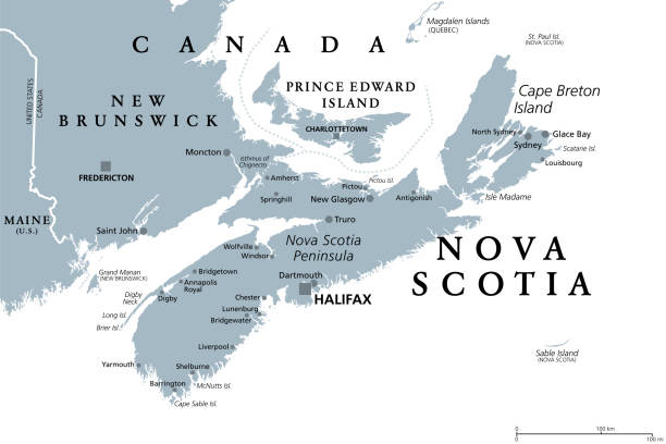
Nova Scotia, Maritime and Atlantic province of Canada, gray political map. Cape Breton Island and Nova Scotia Peninsula, with capital Halifax. Bordering on the Gulf of Maine and on the Atlantic Ocean.
Browse 30+ cape breton island map stock illustrations and vector graphics available royalty-free, or start a new search to explore more great stock images and vector art.
Nova Scotia, Maritime and Atlantic province of Canada, gray political map. Cape Breton Island and Nova Scotia Peninsula, with capital Halifax. Bordering on the Gulf of Maine and on the Atlantic Ocean.
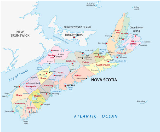
nova scotia administrative and political vector map.

Love from Nova Scotia Vector Watercolor Map Illustration in Pink and Coral Tones. EPS 10 Illustration.

Vintage map of the Siege of Louisbourg in Nova Scotia, Canada. Vintage etching circa late 19th century.
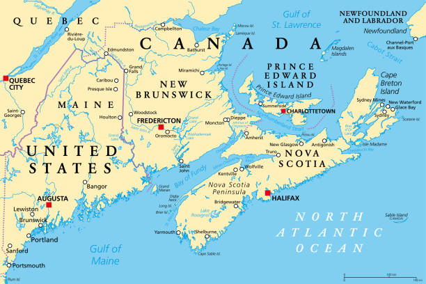
The Maritimes, also called Maritime provinces, a region of Eastern Canada, political map, with capitals, borders and largest cities. The provinces New Brunswick, Nova Scotia, and Prince Edward Island.

Nova Scotia Watercolor Map Illustration in Red and White Colors of the Canada Flag

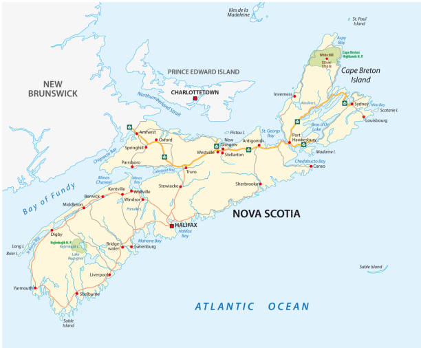
Nova Scotia, Maritime and Atlantic province of Canada, political map. Cape Breton Island and Nova Scotia Peninsula, with capital Halifax. Borders on the Bay of Fundy, Gulf of Maine and Atlantic Ocean.

Prince Edward Island, Maritime and Atlantic province of Canada, political map. The Island, located in the Gulf of St. Lawrence, bordered to New Brunswick and Nova Scotia, with capital Charlottetown.

Cape Breton Island, Nova Scotia, Canada, political map. Rugged and irregularly shaped island on Atlantic coast of North America. Physically separated from Nova Scotia Peninsula by the Strait of Canso.

Cape Breton Island, Nova Scotia, Canada, gray political map. Rugged and irregularly shaped island on the Atlantic coast of North America. Separated from Nova Scotia Peninsula by the Strait of Canso.

3d isometric map of Cape Breton is an island in Canada, isolated vector illustration

The Maritimes region of Eastern Canada, also called Maritime provinces, gray political map, with capitals, borders and large cities. The provinces New Brunswick, Nova Scotia, and Prince Edward Island.

Louisbourg, Cape Breton Island, Nova Scotia, Canada map, 1745. Illustration published 1895. Copyright expired; artwork is in Public Domain.

Vintage engraving of a Map of Cape Breton, Nova Scotia, Canada, early 18th Century

Map of the Cabot Trail, on Cape Breton Island, in the Nova Scotia province of Canada. Cabot Trail highlighted in red, a scenic highway passing along and around the Cape Breton Highlands National Park.

Map of Cape Breton Island, in Nova Scotia province of Canada, with Cabot Trail highlighted in red, a scenic highway passing along and around the Cape Breton Highlands, and with Skyline Trail in blue.

A highly detailed vector map of Nova Scotia, Canada with a multicoloured, pink, purple, red and orange hand painted watercolor texture. Map is isolated on a white background. "Greetings from Nova Scotia" stylized text is added overtop.

A highly detailed vector map of Nova Scotia, Canada with a multicoloured, pink, purple, red and orange hand painted watercolor texture. Map is isolated on a white background. "Greetings from Nova Scotia" stylized text is added overtop.

The Maritimes, the Maritime provinces of Canada, multi colored map. Region of Eastern Canada, consisting of the three provinces New Brunswick, Nova Scotia, and Prince Edward Island. Isolated. Vector

Prince Edward Island, Maritime and Atlantic province of Canada, gray political map. Known as The Island, in Gulf of St. Lawrence, bordering New Brunswick and Nova Scotia, with capital Charlottetown.

A highly detailed vector map of Cape Breton, Nova Scotia with a multicoloured hand painted watercolor texture. Map is isolated on a white background. "Cape Breton" stylized text is added overtop with a star to indicate the location of the city.

Illustrated map of Nova Scotia, Canada with a subtle drop shadow. Vector map illustration.