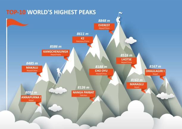
10 worlds highest mountain peaks infographic, flat vector illustration. Everest, K2, Kangchenjunga, Makalu and other Himalayan mountain peaks.
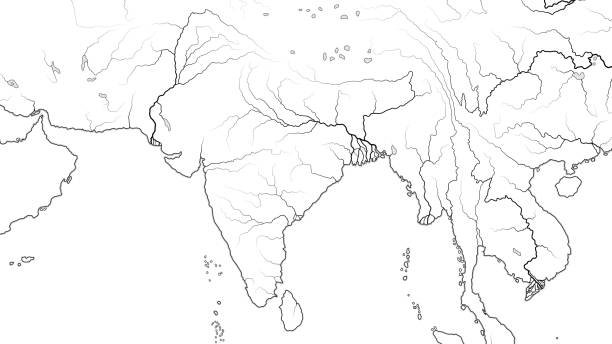
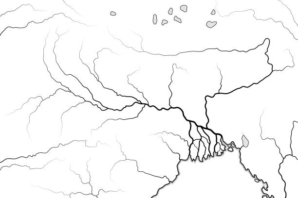
Browse 130+ himalayan mountains world map stock photos and images available, or start a new search to explore more stock photos and images.
10 worlds highest mountain peaks infographic, flat vector illustration. Everest, K2, Kangchenjunga, Makalu and other Himalayan mountain peaks.
Globe map of Asia, satellite view, geographical map, physics. Cartography, relief atlas. 3d render. Thailand, Laos, Cambodia, China. Element of this images are furnished by Nasa https://visibleearth.nasa.gov/images/73801/september-blue-marble-next-generation-w-topography-and-bathymetry/73812l
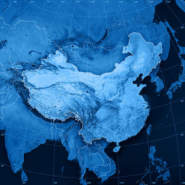
"3D rendering and image composing: Topographic Map of the People's Republic of China. Including country borders, rivers and accurate longitude/latitude lines. High resolution available! High quality relief structure!Relief texture and satellite images courtesy of NASA. Further data source courtesy of CIA World Data Bank II database.Related images:"

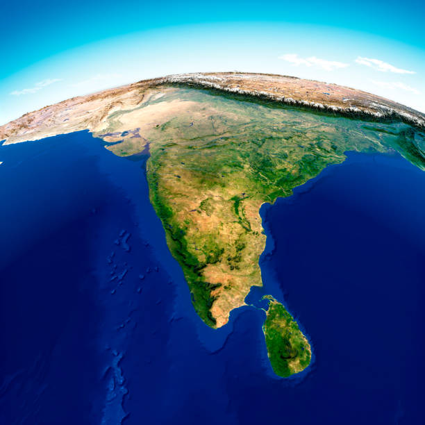
Planet Earth globe, isolated on white. Geography of the world from space, focused on Asia - 3D illustration (Blender software), elements of this image furnished by NASA (https://eoimages.gsfc.nasa.gov/images/imagerecords/73000/73776/world.topo.bathy.200408.3x5400x2700.jpg)

Surface of the Planet Earth viewed from a satellite, focused on East Asia, sun rising on the horizon. Physical map of Himalayas mountains, India and China. 3D illustration (Blender software) - Elements of this image furnished by NASA (https://eoimages.gsfc.nasa.gov/images/imagerecords/73000/73776/world.topo.bathy.200408.3x5400x2700.jpg).
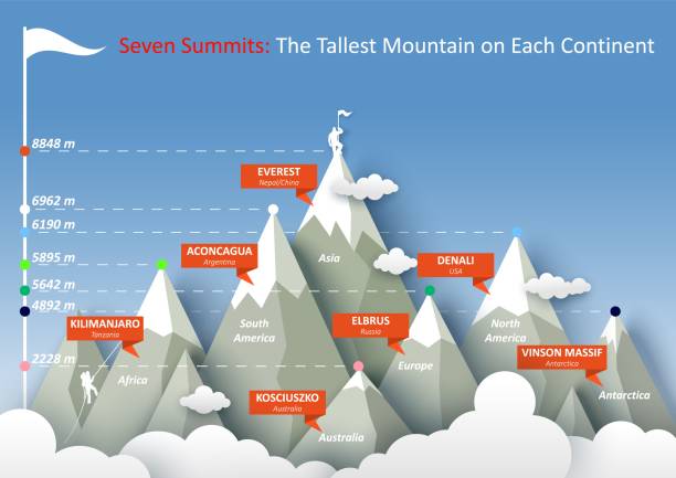
Seven summits infographic, flat vector illustration. The highest mountain peaks of each continent.

Planet Earth globe, highly detailed. Satellite view of the world, focused on Asia - 3D illustration (Blender Software), elements of this image furnished by NASA (https://eoimages.gsfc.nasa.gov/images/imagerecords/73000/73776/world.topo.bathy.200408.3x5400x2700.jpg)

A sleek UFO remains motionless above icy peaks, suggesting technological superiority and observation.

High resolution satellite view of Planet Earth, focused on Asia, Russia, China, India, Himalaya - 3D illustration (Blender software), elements of this image furnished by NASA (https://eoimages.gsfc.nasa.gov/images/imagerecords/147000/147190/eo_base_2020_clean_3600x1800.png)

Encyclopedia Britannica 9th Edition New York Samuel L. Hall 1883 Vol XI

Set of eleven mountains peak badges. Matterhorn. Kilimanjaro. Fuji. Denali. Everest. Mont Blanc. Grand Canyon Rocks. Scribble art.

Nepal - Detailed Map with Regions and Cities. Set of Flags, Globe, Country Outline, Country Location on World Map.

The sign of Darjeeling railway station which is a main railway station in the Indian state of West Bengal. The station lies on UNESCO World Heritage Site Darjeeling Himalayan Railway.

Topographic Map with a marker at the city of Lhasa, Tibet. 3D Rendering with accurate longitude and latitude. Very high resolution available! High quality relief structure!
Set Isometric Unknown search Worldwide Mail and e-mail and Telephone 24 hours support icon. Vector.

Breathtaking sunset over mount Everest summit colored in unbelievable gradient of pink and violet, view from Renjo La pass. Favorable photo.

Beautiful sunset over Everest summit, view from Renjo La pass. Fabulous photo.

"Peaks around Kala Patar (19,000 ft)in the Everst Region"

Set of round frames and elements of the landscape. Mountain top view. Origami element

Nepal - detailed map with regions and cities of the country. Vector illustration.
Set line Medal with star Unknown search Online class and Earth globe icon. Vector.

Breathtaking sunset over mount Everest summit with unbelievable sky gradient from blue to pink and violet, view from Renjo La pass. Fantastic photo.

Southeast Asia on blue planet Earth isolated on white background. Highly detailed planet surface. Elements of this image furnished by NASA.
Set line Worldwide Unknown search and Online quiz test survey icon. Vector.

Globe showing various countries

A dark UFO hovers in the fading light, suggesting the onset of a futuristic alien invasion.

An ominous spaceship floats silently as twilight engulfs the peaks in a futuristic invasion scene.

A dark futuristic craft glides above remote peaks, hinting at a secret extraterrestrial mission.

A quiet snowy landscape remains under the fading light of a possible extraterrestrial visit.

A high-tech spacecraft scans the terrain beneath it, suggesting reconnaissance or invasion.

A fleet of futuristic UFOs flies over a remote valley, suggesting coordinated extraterrestrial activity.

A massive extraterrestrial ring-ship floats above icy terrain in cinematic morning light.

Nepal - detailed map with country regions. Vector illustration

Globe showing various countries

An advanced unidentified flying object looms over frozen peaks, suggesting extraterrestrial presence.

A golden bell of a little temple overlooking on Pokhara lake and Annapurna Chain, with most resembling and holly mountain, Fish Tail. Beautiful weather, blue sky. Green trees.

Sunset over Everest summit, view from Renjo La pass. Fancy photo.

Sunset over Everest mountain with unbelievable sky gradient from blue to pink and violet, view from Renjo La pass. Fascinating photo.

Beautiful sunset over mount Everest summit colored in amazing gradient of pink and violet, view from Renjo La pass. Fetching photo.

Sun over Southeast Asia on blue planet Earth isolated on black background. Highly detailed planet surface. Elements of this image furnished by NASA.