Tectonic plate earth map. Continental ocean pacific, volcano lithosphere geography plates.
Tectonic plate earth map. Continental ocean pacific, volcano lithosphere geography plates.

Pacific Ring of Fire, map with oceanic trenches. Also known as Rim of Fire, and as Circum-Pacific Belt. Region around the rim of the Pacific Ocean, where many volcanic eruptions and earthquakes occur.
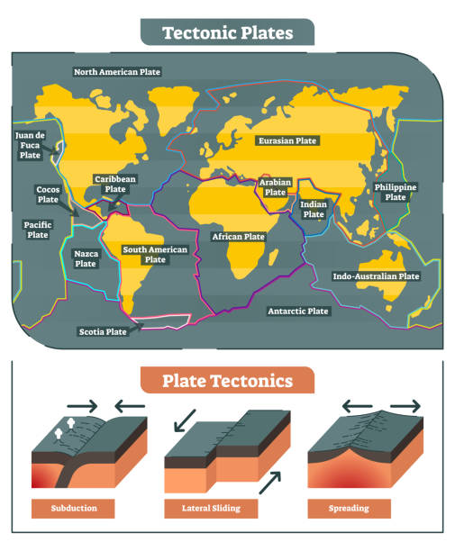
Tectonic Plates world map vector diagram and tectonic movement illustrations showing subduction, lateral sliding and spreading process.

Convergent plate boundary created by two continental plates that slide towards each other. Digital illustration.

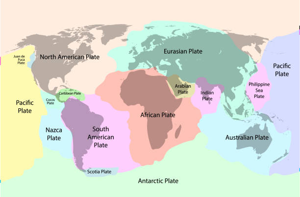
Principal tectonic plates of the Earth, world map. The sixteen major pieces of crust and uppermost mantle of the Earth, called the lithosphere, and consisting of oceanic and continental crust. Vector

Mediterranean Basin, Middle East and North Africa, tectonic map. The plate movements between the continents Eurasia, Africa and Asia causing earthquakes, volcanic eruptions and drifting landmasses.

Tectonic plate earth map. Continental ocean pacific, volcano lithosphere geography plates.

Flat Earth in space with sun and moon. Flat planet Earth conspiracy theory. The flat Earth model is an archaic conception of Earth's shape as a plane or disk. Elements of this image furnished by NASA. ______ Url(s): https://visibleearth.nasa.gov/collection/1484/blue-marble?page=1 https://www.nasa.gov/content/goddard/one-giant-sunspot-6-substantial-flares/ https://images.nasa.gov/details-GSFC_20171208_Archive_e001861
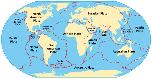
Map of the principal tectonic plates of the Earth. The sixteen major pieces of crust and uppermost mantle of the Earth, called the lithosphere, and consisting of oceanic and continental crust. Vector

Principal tectonic plates of the Earth, gray map. The sixteen major pieces of crust and uppermost mantle of the Earth, called the lithosphere, and consisting of oceanic and continental crust. Vector.
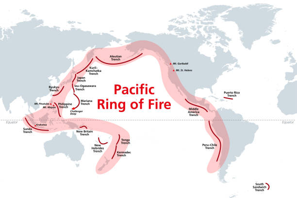
Pacific Ring of Fire, world map with oceanic trenches. The Rim of Fire, or also Circum-Pacific Belt. Region around the rim of the Pacific Ocean, where many volcanic eruptions and earthquakes occur.

Section of the Earth, layers and core. Cutaway and horizontal section, satellite view of the American continent. Explosion and cataclysm. Debris in space. 3d render. Element of this image are furnished by Nasa

Tectonic plate earth map. Continental ocean pacific, volcano lithosphere geography plates.

Earth structure, earth section, division into layers, the earth's crust and core. 3d rendering. Element of this image is furnished by NASA

Trans-Mexican Volcanic Belt, map with the major active volcanoes of Mexico. Also known as Transvolcanic Belt and locally as Sierra Nevada. Active volcanic belt, that covers central-southern Mexico.

Plate of the earthquake which exists in Japan.

Earth structure, division into layers, the earth's crust and core. 3d rendering. I've created it with a 3d software. This is the link of the earth map. http://visibleearth.nasa.gov/view.php?id=57730

Section of the Earth, layers and core. Cutaway and horizontal section, satellite view of the American continent. Explosion and cataclysm. Debris in space. 3d render. Element of this image are furnished by Nasa

Earth structure, earth section, division into layers, the earth's crust and core. 3d rendering. Element of this image is furnished by NASA

Earth structure, earth section, division into layers, the earth's crust and core. 3d rendering. Element of this image is furnished by NASA

Earth structure, division into layers, the earth's crust and core. 3d rendering. I've created it with a 3d software. This is the link of the earth map. http://visibleearth.nasa.gov/view.php?id=57730

Earth structure, division into layers, the earth's crust and core. 3d rendering. I've created it with a 3d software. This is the link of the earth map. http://visibleearth.nasa.gov/view.php?id=57730

Earth structure, division into layers, the earth's crust and core. 3d rendering. I've created it with a 3d software. This is the link of the earth map. http://visibleearth.nasa.gov/view.php?id=57730

The world map is made with Natural Earth 2 (This data derived from Natural Earth 1 portrays the world environment in an idealized manner with little human influence); Added Geographical plate boundary, Only land and Enhanced display of land mountainous terrain, no ocean.

Earth structure, earth section, division into layers, the earth's crust and core. 3d rendering. Element of this image is furnished by NASA

Jupiter, the giant of the solar system, impresses not only with its immense size and swirling atmosphere but also with its family of moons—miniature worlds in their own right. Most notable are the Galilean moons: Io, Europa, Ganymede and Callisto, discovered by Galileo Galilei in 1610. Far from being mere rocky spheres, each of these satellites possesses unique features that make them prime targets for scientific exploration. Io is the most volcanically active body in the solar system, its surface scarred by sulphur geysers and lava flows. Europa, cloaked in a shell of ice, is thought to harbour a subsurface ocean, potentially capable of supporting life. Ganymede, the largest moon in the solar system, is even bigger than Mercury and has its own magnetic field. Callisto, meanwhile, bears an ancient, cratered surface—an open archive of cosmic history.

Exploration of new worlds and galaxies. Stars and planets, alien worlds. Communications and contacts. Fast internet line. Satellites and space. Particles. New discoveries. 3d render

Jupiter, the giant of the solar system, impresses not only with its immense size and swirling atmosphere but also with its family of moons—miniature worlds in their own right. Most notable are the Galilean moons: Io, Europa, Ganymede and Callisto, discovered by Galileo Galilei in 1610. Far from being mere rocky spheres, each of these satellites possesses unique features that make them prime targets for scientific exploration. Io is the most volcanically active body in the solar system, its surface scarred by sulphur geysers and lava flows. Europa, cloaked in a shell of ice, is thought to harbour a subsurface ocean, potentially capable of supporting life. Ganymede, the largest moon in the solar system, is even bigger than Mercury and has its own magnetic field. Callisto, meanwhile, bears an ancient, cratered surface—an open archive of cosmic history.
Geodetic survey engineering vector flat line icons
© 2025 iStockphoto LP. The iStock design is a trademark of iStockphoto LP. Browse millions of high-quality stock photos, illustrations, and videos.
Do Not Sell or Share


